
Organisation Info
Organisational Chart
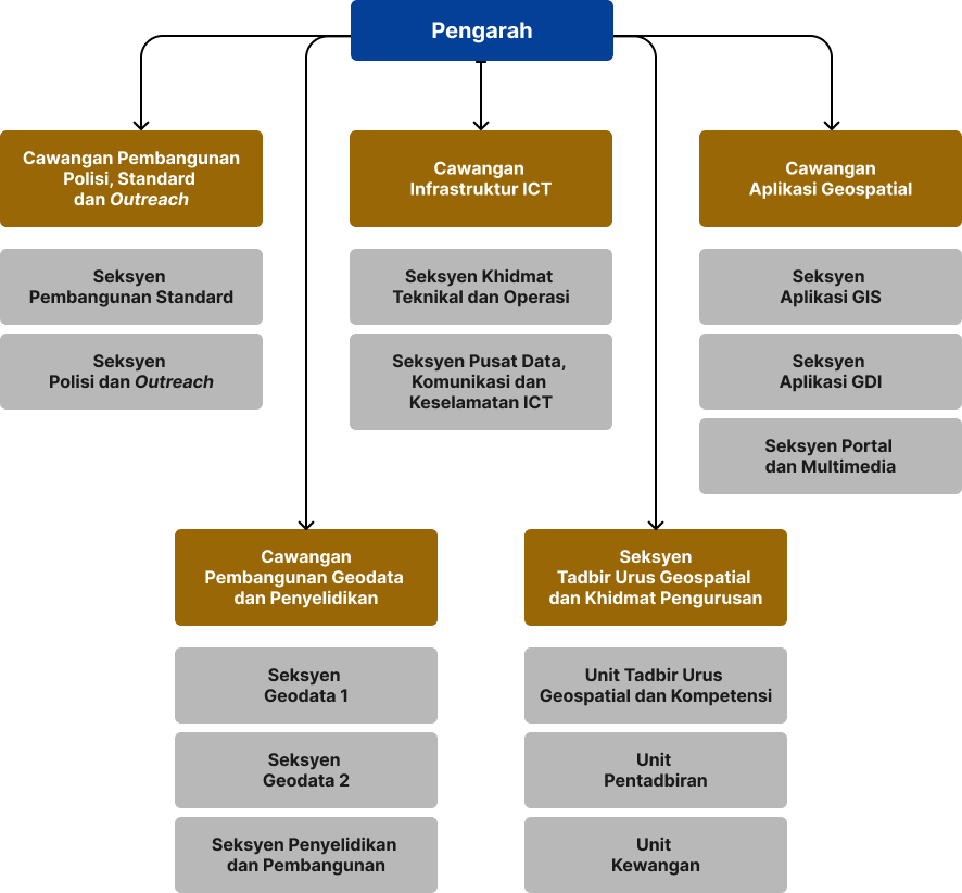
Functions of the Divison
- Ensuring fundamental and non-fundamental data for the categories of Built Environment, Hydrography, Transportation, Aeronautical, General, Soil, Vegetation, Hypsography, Demarcation, Geology, Special Use, and Utility comply with the established MyGDI standards and quality.
- Planning, implementing, and coordinating research activities for the development needs of geospatial data, technology, applications, and GIS software..
- Managing and reviewing circulars and guidelines related to geospatial activities.
- Developing and coordinating geospatial standards activities alongside participation in Malaysian standardization efforts.
- Promoting the MyGDI through various media publications and outreach activities targeting government agencies, private sectors, and academia..
- Managing national and international geospatial conferences, seminars, and official visits.
- Developing and managing the National Geographical Names Database and Gazetteer (PDNG).
- Managing data applications for the sharing and release of geospatial data under the MyGDI..
- Planning, managing, implementing, maintaining, monitoring, and providing consultation services for ICT services encompassing data center infrastructure, networking, communication, security, and ICT operations.
- Planning, developing, enhancing, maintaining, and monitoring GIS applications through the collaborative Malaysia Geospatial Online Services (MyGOS) Platform.
- Planning, developing, enhancing, maintaining, and monitoring the development of support applications.
- Planning, developing, enhancing, maintaining, and monitoring portals and multimedia projects.
- Provide technical assistance and training for GIS software and applications.
Planning, managing, and coordinating:
- Human Resources
- Finance and Procurement
- Management Services
Organisation Chart
Fungsi Cawangan
- Memantapkan Geospatial Data Center (GDC) bagi dataset fundamental dan non fundamental mematuhi standard dan kualiti yang telah ditetapkan.
- Melaksanakan penyelenggaraan dan pengemaskinian dataset GDC fundamental dan non fundamental bagi kategori Built Environment, Hydrography, Transportation, Aeronautical, General, Soil, Vegetation, Hypsography, Demarcation, Geology, Special Use dan Utility di peringkat persekutuan dan negeri.
- Melaksanakan penyelidikan bagi keperluan pembangunan data geospatial, teknologi, aplikasi dan perisian GIS.
- Merancang penyelidikan yang sesuai bagi keperluan pembangunan geospatial PGN.
- Mengurus dan mengkaji semula surat pekeliling dan garis panduan berkaitan geospatial.
- Membangun dan menyelaras aktiviti standard berkaitan geospatial serta penglibatan dalam aktiviti standard Malaysia.
- Mempromosi Program MyGDI menerusi penerbitan pelbagai media serta aktiviti outreach melibatkan agensi kerajaan, sektor swasta dan akademia.
- Mengurus persidangan, seminar dan lawatan berkaitan geospatial di peringkat kebangsaan dan antarabangsa
- Membangun dan mengurus Pangkalan Data Nama Geografi dan Gazetir Kebangsaan (PDNG).
- Membangun, menambah baik, menyelenggara dan memantau portal MyGeoportal dan projek multimedia.
- Membangun, menambah baik, menyelenggara dan memantau aplikasi GIS yang dibangunkan menggunakan platform Malaysia Geospatial Online Services (MyGOS)
- Membangun, menambah baik, menyelenggara dan memantau aplikasi GIS yang dibangunkan menggunakan platform Malaysia Geospatial Open Source (MyGEOSC)
- Merancang membangun, melaksana dan memantau pembangunan aplikasi berdasarkan standard.
- Mengurus dan menyelenggara aplikasi Program MyGDI
- Merancang, membangun, melaksana dan memantau pembangunan aplikasi dalaman PGN
- Menyelaras hal ehwal pentadbiran dan keselamatan PGN
- Menyelaras hal ehwal perkhidmatan pegawai di PGN
- Membantu hal ehwal mesyuarat dan program-program PGN
- Menyelaras hal ehwal pembangunan kompetensi dan latihan pegawai di PGN
- Menyelaras hal ehwal kewangan PGN