
MyGDI Governance
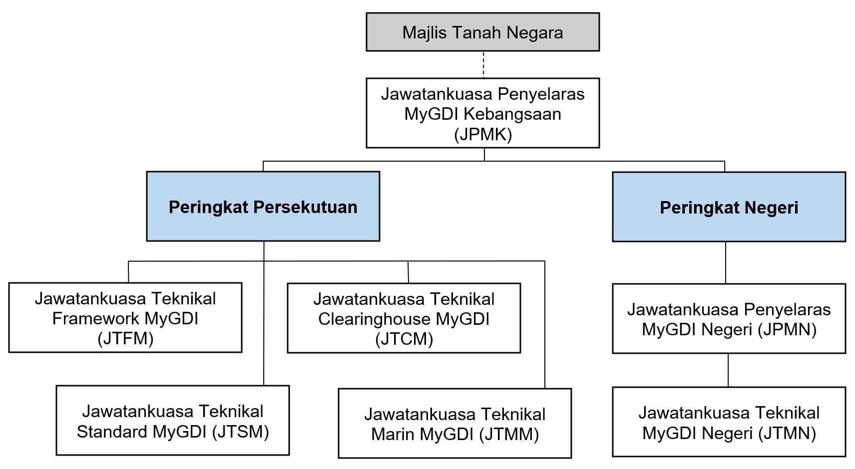
MNCC responsibilities within the Government of Malaysia in:
a) Setting the policies and guidelines for the development and implementation of MyGDI;
b) Establishing working committees as periodically required;
c) Coordinating and monitoring the development and implementation of MyGDI through committees established under MNCC; and
d) Ensuring financial, human resource, and technological resources are met for MyGDI activities
MFTC responsibilities within the MyGDI National Coordinating Committee (MNCC) in:
a) Coordinating effective geospatial data sharing through MyGDI;
b) Coordinating the development and utilization of MyGDI framework data;
c) Monitoring policies and guidelines implementation related to MyGDI framework;
d) Promoting awareness and commitment among agencies to develop data framework;
e) Coordinating standardization use in national geospatial information;
f) Coordinating geospatial information sharing via MyGDI’s infrastructure and digital services;
g) Coordinating data sharing and geospatial metadata publication;
h) Coordinating collaboration in development and MyGDI’s program implementation via existing committees;
i) Providing advisory services in geospatial information development;
j) Coordinating financial requirement, human resource, and talent development needs for MyGDI; and
k) Planning and developing Research, Development, Innovation and Commercialisation (RDIC) for MyGDI
MCTC responsibilities within MyGDI National Coordinating Committee (MNCC) in:
a) Developing policies and guidelines related to Clearinghouse operation for MyGDI;
b) Determining resource requirements for development and operation of MyGDI Clearinghouse; and
c) Coordinating and monitoring the activities related to the operation and usage of MyGDI Clearinghouse.
MSTC responsibilities within the MyGDI National Coordinating Committee (MNCC) in:
a) Coordinating and monitoring the use of geospatial information standards; and
b) Collaborating with the Department of Standards Malaysia (DSM) for Geographic information/Geomatics Standards and other technical standard committees to develop and update the Malaysian Standard (MS).
MMTC responsibilities within the MyGDI National Coordinating Committee (MNCC) in:
a) Coordinating data sharing, preservation, conservation, and storage of marine geospatial data (covering areas beyond 3 nautical miles from the low water mark to the open sea, as per the National Land Code, Section 5 & New Map of Malaysia 1979).
b) Identifying types of data that can be shared between government agencies and users. Establish application procedures for marine geospatial data and information needed by users.
c) Coordinating the collection, storage, and maintenance of marine spatial data for national use, especially for national defence.
d) Promoting awareness of the importance of marine development management, especially seabed exploration.
e) Identifying the scope of marine geospatial infrastructure development, including technology, policies, standards, and requirement of current and future marine users;
f) Providing advisory services on safety, financial, and social issues related to marine geospatial data sharing
MSCC responsibilities within the MyGDI National Coordinating Committee (MNCC) in:
a) Adopting national geospatial policies and standards that are specified;
b) Coordinating and monitoring geospatial data sharing at the state level.
c) Establishing and appointing members for the MyGDI State Technical Committee (MSTC) and monitoring state program implementation.
d) Ensuring financial, human resource, and technological needs are met for state MyGDI activities; and
e) Reporting MyGDI’s state program activities.
MyGDI State Technical Committee (MSTC) responsibilities within the MyGDI State coordinating Committee (MSCC) in:
a) Implement the geospatial policies and standards specified;
b) Implement geospatial data sharing thru MyGDI’s state programs;
c) Ensure resource requirements (financial, human capital, technology) are fulfilled for MyGDI’s state;
d) Implement and coordinate MyGDI activities at the state; and
e) Establish and appoint working groups as needed for MyGDI’s state implementation.