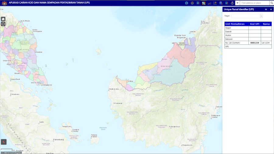
Unique Parcel Identifier (UPI)
This application was developed to assist users in referencing standardized codes and names of administrative land boundaries.
The UPI application can display information in spatial and textual form for the display of land parcels and land boundaries that have been finely measured.
The use of a standardized UPI ensures that the objectives of data sharing between agencies are successfully achieved.
- Facilitate the implementation and integration of application systems within and between agencies
- Facilitate the sharing of geospatial information
- Assisting agencies in the application system development
- Provides guidance on implementing uniform documentation across agencies
- Quick and easy search with results shown in textual and spatial form.
- Basemap option
- Download documents in PDF format
- Download data in Excel format
- Print maps based on search results
Land Administration Codes and Names by States
The Land Administration Boundary Code and Name Document was published in 2011 and 2023.
The latest list of Land Administration Codes and Names are available here >>
| No. | Land Administration Codes and Names | Download |
|---|---|---|
| 1 | Land Administration Codes and Names: Johor | |
| 2 | Land Administration Codes and Names: Kedah | |
| 3 | Land Administration Codes and Names: Kelantan | |
| 4 | Land Administration Codes and Names: WP Kuala Lumpur | |
| 5 | Land Administration Codes and Names: Melaka | |
| 6 | Land Administration Codes and Names: Negeri Sembilan | |
| 7 | Land Administration Codes and Names: Pahang | |
| 8 | Land Administration Codes and Names: Perak | |
| 9 | Land Administration Codes and Names: Perlis | |
| 10 | Land Administration Codes and Names: Pulau Pinang | |
| 11 | Land Administration Codes and Names: WP Putrajaya | |
| 12 | Land Administration Codes and Names: Selangor | |
| 13 | Land Administration Codes and Names: Terengganu | |
| 14 | Land Administration Codes and Names: WP Labuan | |
| 15 | Land Administration Codes and Names: Sabah | |
| 16 | Land Administration Codes and Names: Sarawak |